
Winter Park is 3,081 acres across seven territories, and even people who ski here regularly find new ways to end up on the wrong side of the mountain. A map helps. Knowing which map helps more.
Below is every map you might need for the 2026/2027 season, what each one is actually for, and the two you should have on your phone before you leave the house.
All links go to Winter Park Resort's official map pages, which are updated for the current season. We stopped linking individual PDFs because they change every year and go stale the moment the resort publishes a new one.
Start Here: All Official Winter Park Maps
View and download all Winter Park Resort maps
This is the resort's own maps hub and the single link worth bookmarking. Trail map, base area, parking, uphill, grooming and more, always in the current season's version.
The Two Maps to Have on Your Phone
1. The Trail Map
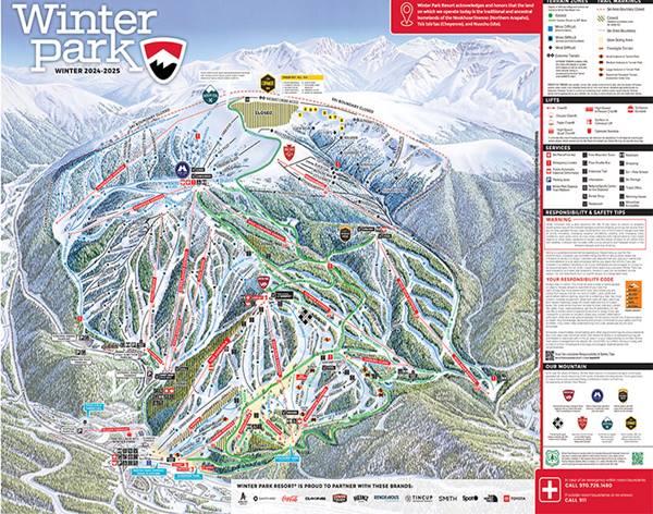
The one everybody means when they say "trail map." Shows all seven territories, every named run with its difficulty rating, and every lift.
Use it to: figure out how to get from Mary Jane back to the Winter Park base without an unplanned detour, find a green route down for a nervous skier, or work out which lift actually gets you to Parsenn Bowl.
Local's tip: download it before you arrive. Cell service on the mountain is patchy and a screenshot works when a webpage will not.
2. The Grooming Map
Updated daily, showing exactly what got groomed overnight. This is the map locals actually check, and it is the difference between finding fresh corduroy at 9am and finding yesterday's moguls.
Use it to: plan your first three runs. On a non-powder day, chasing the grooming report is the single best way to have a great morning.
The Rest of the Maps, and When You Need Them
Base Area Map
Shows the Village layout: lifts, ticket windows, rental shops, dining, restrooms and where the Gondola and Cabriolet actually load.
Use it if: it is your first visit. Fifteen minutes with this map on arrival evening saves an hour of wandering in ski boots the next morning.
Parking Maps (Winter Park Base and Mary Jane)
Two separate maps, one for each base area, showing lot locations, shuttle stops and paid versus free parking.
Use it if: you are driving up. Parking changes between seasons and lots fill on weekends and holidays. Check the resort's current parking information alongside the map, since policies shift more often than the map does.
Or skip it entirely: the free town shuttle runs between Winter Park, the base and Fraser. See our getting around Winter Park page.
Ski School Meeting Spots Map
Shows exactly where each lesson type gathers, which matters enormously on a morning where you are already running late with three kids.
Two things worth knowing before you look at it:
- Kids lessons typically meet at Sorenson Park. Full-day kids lessons meet at 9:00am and run 9:15am to 3:00pm.
- Adult lessons typically meet on snow between the Arrow and Gemini lifts at the Winter Park base. Morning half days meet at 9:00am, afternoons at 12:45pm.
More in our Winter Park lessons guide.
Uphill Access Map
For anyone skinning or hiking up rather than riding a lift. Shows permitted routes and access points.
Use it if: you plan to earn your turns. Read the uphill access policy alongside it, because permitted routes and hours change with resort operations, grooming and snowmaking. This is not a map to freestyle with.
Snowshoe Map
Designated snowshoe routes on and around the resort. Snowshoeing is the most accessible winter activity here, requires no skill whatsoever, and is a great rest-day option for a mixed group.
The resort also runs guided Sunset Snowshoe Tours that take you up the Gondola and out onto a forest trail at twilight, typically Thursday through Saturday. Worth booking.
Town Map
Covers the Town of Winter Park and Fraser rather than the resort: restaurants, shops, the rec center and the shuttle routes.
Use it with: our guide to the best restaurants in Winter Park, which lists current addresses, phone numbers and closed days. Six local restaurants shut at least one day a week, and no map will warn you about that.
Better Than Any Map: The Live Tools
A trail map tells you what exists. These tell you what is actually happening today.
- Mountain Report. Open lifts, open terrain, overnight snowfall, current conditions. Check it before you leave the house, every single day.
- Live Cameras. See the base and the mountain in real time. Excellent for settling arguments about whether it is actually snowing.
- The Winter Park Resort app. GPS tracking on the trail map, live lift status and terrain openings in your pocket. Download it before you arrive rather than in a lift line on bad signal.
Navigating Winter Park: Three Things Maps Do Not Tell You
1. Weekends start an hour earlier now. New for 2026/2027, lifts open at 8:00am on Saturdays and Sundays from December 5, 2026 through April 4, 2027. Plan your first three runs accordingly, because that hour on fresh grooming is the best skiing of the day.
2. Mary Jane keeps her own calendar. She typically opens in January, weeks after the main mountain, and closes earlier in spring. A trail map will show you Mary Jane in December; the mountain report will tell you she is closed. Always check the report, not just the map.
3. The Corridor Trail is how the two base areas connect. It links Mary Jane and the Winter Park base, and several slopeside properties use it for ski access. It is a real run and requires the ability to ski a blue comfortably, which the map does not communicate.
For a proper breakdown of where to actually go, read our guide to which territory to ski at Winter Park and our one-day ski itinerary, which is essentially a trail map with opinions.
A Safety Note on the Upper Mountain
Parsenn Bowl, Eagle Wind and The Cirque all appear on the trail map year-round, but they open later in the season and close in wind and poor visibility. The Cirque in particular is expert-only ungroomed terrain with a backcountry feel inside the boundary.
If you are heading into trees or ungroomed terrain, go with a partner and keep them in sight. See Winter Park's safety and conduct information and our high country safety guide.
Stay Where You Do Not Need a Parking Map
The easiest way to simplify mountain navigation is to start closer to it. Our ski-in ski-out rentals and Winter Park Resort area properties put you a short walk from the lifts, which makes an 8:00am weekend first chair genuinely achievable.
Browse private homes, condos, townhomes, the Luxury Collection, or homes with a private hot tub.
Check current lodging deals, lift tickets and passes and ski rental deals, then browse all Winter Park vacation rentals or call our local team at 970-722-0707.
We ski this mountain on our days off. Tell us your ability level and we will tell you where to point yourself.
More Winter Park reading:
- Which Territory Should You Ski at Winter Park?
- The Perfect 1-Day Ski Itinerary at Winter Park
- Best Restaurants in Winter Park, CO
Maps are published and maintained by Winter Park Resort and are updated each season. Terrain availability, lift operations and parking policies change with conditions. Always check the current mountain report before heading up.